A survey data collector, already in your pocket.
Import your existing points, set up over a known or assumed point, and shoot. ChainLink records your shots and works out coordinates in 2D or full 3D, then runs the COGO — inverse, intersections, resection, traverse adjustment, areas, and stakeout to points, lines, and curves. Works with no signal, with whatever total station you're running, and sends the file back to the office when you're done.
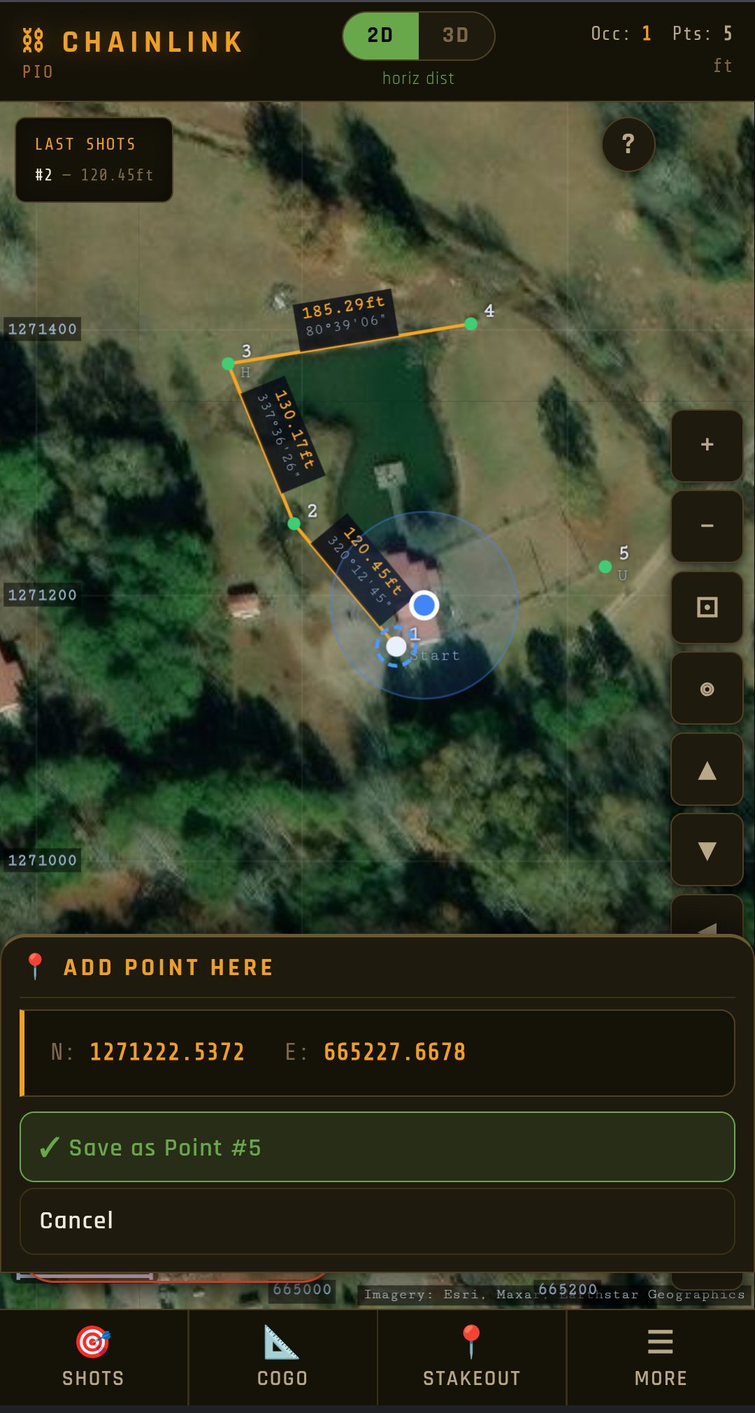
And because it lives on a phone, it can do what a data collector can't: one GPS fix puts your job on real State Plane coordinates, draws your work over live aerial imagery, shows where you're standing, and walks you to any point.
I work on a survey crew. My last outfit ran high-tech gear. Then I moved across the country to support family, and the field tool I was handed at the new job was an HP 48GX — a graphing calculator from the early '90s with survey programs loaded on it, far too antiquated for modern tasks, in my opinion. I had a smartphone in my pocket the whole time, but I couldn't find a single app that would record measurements and run COGO on a phone.
So I built what I wanted: something that runs on the phone already on me and works with no signal.
It's grown well past what I first needed. It works in 2D or full 3D, handles the heavier COGO — resection, intersections, traverse adjustment, areas with curved boundaries — and stakes out points, lines, and curves. It'll reduce two-face shots, average points for tighter control, apply atmospheric and scale corrections, and export to CSV, DXF, LandXML, KML, or a PDF field book for the office. Now it'll even put your work on live aerial imagery from one GPS fix. I hope it's useful for you.
How it works.
ChainLink is a single self-contained app — nothing to install, no account, and it keeps working with no signal once it's loaded. It turns the angles and distances from the gun into real coordinates, draws them on a plot you can see and edit, and does the layout math.
Whether you've never had a collector, yours just quit in the field, or you're laying out your own project with a borrowed or used gun — it's the same tool, and you don't have to be licensed to use it.
The tools it has.
- Turns your shots into coordinates, with the weather and prism corrections built in
- Distance and direction between any two points, and find points where lines cross
- Guides you to lay out a point, a line, or a curve — tells you which way to move the rod
- Draw lines and curves, get areas and acreage, work along a baseline
- Starts a job on your state's official coordinate grid from one GPS fix, with the ground elevation filled in from USGS survey data
- Shows your work over live aerial imagery or USGS topo maps, with your position as a blue dot — and saves the imagery for offline use
- Rolls the aerial photo back through the years — the fence line before the subdivision, the pond before it was filled, the tree line the old deed calls for
- Walks you to any point with live distance and direction — handy for finding a corner in the brush
- Shows NGS survey monuments on the map — condition-colored, with published State Plane coordinates and the government's directions to each disk
- Plots deeds from pasted text or a photo — boundary, carve-outs, and easements at their right-of-way width, with net acreage from true arc math
- Reads a coordinate list off a plan sheet — paste it, or photograph the table; nothing in the job is overwritten
- Holds as many jobs as you have work — each with its own points, records and settings, all on the phone
- Send your work to the office — CSV, DXF, LandXML, KML for Google Earth, a PDF plot or field book
- Works with no signal. Pan, zoom, and tap the plot to fix anything
It knows where it's standing.
A data collector only knows the numbers you feed it. Your phone also knows where it is on Earth — so ChainLink uses that.
Stand at your starting point and take one GPS fix: the job lands on your state's real coordinate grid, the aerial photo lines up behind your linework, and from then on a blue dot shows where you are on your own survey. Pick any point and the app gives you live distance and direction to walk to it.
Scouting a property? Drop a pin at anything you find — an iron, a gate, a culvert — and it's stored as a point, clearly tagged as GPS-grade so it's never confused with an instrument shot. The precise work still belongs to the gun; the phone gets you there and shows you the whole picture.
Paste a deed. Watch it draw itself.
Paste a legal description — from a deed search, a title commitment, or a photo of the paper — and ChainLink reads the calls: bearings, distances, curves, even the old units (chains, links, rods, poles, varas, meters). Then it plots the tract on the aerial imagery, right where the land is.
It reads the whole record, not just the perimeter. Carve-outs ("less and except") and easements come in as their own figures, each placed by its own tie courses from the point of beginning — easements drawn at their stated right-of-way width. Net acreage comes out with curves computed as true arcs, not chord shortcuts.
Aliquot descriptions work too — “the West Half of the Southwest Quarter of Section 34” has no bearings or distances in it at all, so ChainLink plots it against the PLSS fabric at nominal GLO dimensions. Then, once you've measured the four corners of the parent forty, it re-derives the parcel by proportion along your actual lines, the way the GLO method says to. A parent that's forty feet short and skewed gives you the correspondingly lopsided parcel — not a clean rectangle in the wrong place.
When a description doesn't close, the app tells you why. It reads the misclosure and names the likely cause: a transposed digit, a flipped quadrant, a dropped course, an angle blunder at one station — with the correction that would close the figure, and what the misclosure would drop to. It also checks the plotted area against the deed's own recited acreage, which catches a duplicated or missing course that closure alone can never see. Nothing is ever applied for you; it's shown, and you check it against the paper.
Bring in the neighbors, too: each deed comes in as its own record, and shared corners and courses snap together so you can assemble the block the way the descriptions describe it.
And it's honest software: a carve-out that lands outside its parent tract gets flagged on the plot, not painted over. Sometimes that's a figure waiting to be placed. Sometimes you've just found a defect in the record — the kind of thing a retracement surveyor gets paid to notice.
Then the part no desktop deed program can do: put the phone in your pocket and walk to the corners. Every plotted corner is a live point — stakeout, inverse, and GPS navigation all work on it.
One honest tip: the built-in 📷 camera works offline, but its text reading is rough. Google Lens reads deeds far better — snap the page with Lens, copy the text, and paste it in. A scanner app that makes searchable PDFs (Adobe Scan, Microsoft Lens) works even better for multi-page deeds: the app reads the PDF's text directly.
The government's survey marks, on your map.
Scattered across every county are NGS survey monuments — brass disks set in concrete and bridge abutments, some over a century old, each with an officially published position. Finding them used to mean a government website and a stack of datasheets.
In ChainLink they just appear on your imagery: little triangles, colored by their last recovery — green for found-in-good-shape, amber for rough or long-unvisited. Confirmed-destroyed marks stay hidden so they never waste your morning. Tap one and you get the whole story: what the disk is, what's stamped on it, what it's set in, when someone last found it — and on request, the government's own walking directions to it, written by whoever set or recovered it.
Then the part that matters: the card carries the mark's published NAD 83(2011) State Plane coordinate, already in your job's grid. Create a point from it and that official value is in your job — export it, stake to it, tie your traverse to it. It's the coordinate an RTK rover would navigate to, and it connects your work to the National Spatial Reference System through a brass disk half a mile from the job.
Fetched once over mobile data, stored with the job — dead zones don't matter after that.
Add it to your device like an app.
ChainLink is a web app — open it once and add it to your home screen, then it launches full-screen and runs offline. No store, no download.
Android
- Open the app in Chrome
- Tap the ⋮ menu, top-right
- Tap Install app (or Add to Home screen)
iPhone / iPad
- Open the app in Safari
- Tap the Share button
- Tap Add to Home Screen
PC / Mac
- Open the app in Chrome or Edge
- Click the install icon in the address bar
- Click Install
ChainLink is in beta — everything in it is free while it's in beta. No account, no card, nothing to sign up for; open it and it's yours.
Open the App →